Nature and Plastic project for France

Hey ! :grin:

I am trying to create the Nature and Plastic projects for France but I’m facing some problems with it.

I need to create two projects :

  1. FR Terrestrial Nature and Plastic
  2. FR Marine Nature and Plastic

I take example on :

  1. AU Terrestrial Nature and Plastic (https://www.inaturalist.org/projects/au-terrestrial-nature-and-plastic)
  2. AU Marine Nature and Plastic (https://www.inaturalist.org/projects/au-marine-nature-and-plastic)

Also as you can see, there is two places, one terrestrial and one marine (Exclusive Economic Zone).

The currently existing iNat place for France is : https://www.inaturalist.org/places/france
Unfortunately, this is only the mainland, the metropolitan part of France.
In OpenStreetMap, France is quite well defined : https://www.openstreetmap.org/relation/2202162#map=1/-19/4 (Antartic part is missing but anyway, it’s far better than in Google Earth). It’s hard to believe but yes, Google Earth is wrong on that. They should say “France métropolitaine”. They do the same for UK by the way, so I think there is some kind of decision from them behind this fact. I guess it’s because It’s more user friendly even if it’s administratively wrong. This is also a sensitive political topic.

For a project like Nature and Plastic it would be very sad to not take into account the islands and all marine areas. Currently, they are considered as “Country”, for example Mayotte : https://www.inaturalist.org/places/mayotte

Also I decided to try to create a new place called “France métropolitaine et d’outre-mer” for the terrestrial project basing myself on some existing stuff. I took : https://www.openstreetmap.org/relation/2202162#map=4/-39.06/75.85

I struggled a bit but I found the solution on the forum and successfully imported the thing in QGIS (nice tool by the way). My first export gave me a 12 MB which is > 1MB (I’m not a curator). I removed useless metadata that were added and I was able to have a file of 1,92 MB. Still not good for the limit.

Also then, I tried to reduce the size by simplifying but I’m still blocked.

  1. When I take the polygon layer, I cannot directly use the native “Simplify…” tool from QGIS
  2. Same problem for the great tool “Geodesic line decimate” from the plugin “Shape tools”, it’s not possible to apply to a polygon layer
  3. When I apply to a line layer (after using Polygon to lines and fixing the geometric errors…), I can apply the simplification with great results, I remove duplicated peaks, I refix geometric errors, I export in KML and I finally have a 0,97 MB file !!

Now, when I upload it to iNaturalist for a new place I have the error message “Place geometry is too big to be imported, Place geometry can’t be empty”.

Now, what I am supposed to do to have this place for the Nature and Plastic project ?
Am I supposed to give up or is there any solution ? :thinking:

I spend my whole day on it and it’s a bit frustrating to be blocked after so much efforts to get the file under 1 MB…

PS: I guess doing the marine place will be another big problem…
2 Likes

I would suggesting not using a place at all for your project - you will have to make a traditional project for this, and while it’s possible to restrict observations to a place, I don’t think it’s necessary. Just be explicit in the project description and title.

5 Likes

Thanks @tiwane I’m the creator of the Nature & Plastic umbrella project. All the country projects created so far are using the traditional project as the obs have to be added manually: https://www.inaturalist.org/projects/nature-and-plastic

For NZ is was easy to add a place/boundary to the Marine & Terrestrial NZ projects, but has been more difficult for other countries which have territorial areas around the world like islands, eg US & FR.

@valentinhamon I’m sorry trying to add the place has been so difficult for you, at the time we created the umbrella project, I think we naively assumed all countries & their territories were in the places list. Maybe for the Terrestrial project, use the mainland France place which will at least make an outline on the umbrella map, but add to the description that terrestrial observations from French territories like Tahiti etc, can also be added to the project.

I think for the FR Marine project, @tiwane’s suggestion to be explicit in the description that observations for that project must be from the French mainland coastline, or French territorial waters, is possibly the only solution. It may cause a few problems in the future if for example someone from Belgium or Italy adds an observation from their coastline to the French project, but hopefully they will be few obs.

1 Like

If each seperate territory has it’s own iNat “place” already created, then you could just list them individually in the places criteria for the project? I’m not sure what the maximum number of places is, but I’m pretty sure you can add multiple…

1 Like

I think when you create a traditional project, you can only add one place. From memory either the US or AU project creators tried to add more than one place and couldn’t? I could be wrong …

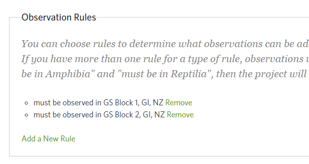
I just made a couple test places and a test project. It only allows you to add one place, but if you save it and then go back in, it allows you to add another:
image
So it can be done, just really clunky…
A quick test of adding observations to make sure it’s not “AND”, ie the observation must be in both places to qualify, and it seems to allow the obs to add ok.
image

1 Like

You can have multiple “must be in place” rules, but you can only show one place on a map. the map view does not restrict observations, I think, you need to have project rules for place and other restrictions.

Yeah, the selecting of a place in that first “location” box just centers the map around that place. I made Auckland the centre of my test project, but the two places that I added to the rules are two blocks in my neighbourhood in Gisborne:
https://inaturalist.nz/projects/gs-test


That looks like a good solution. For the French projects, in Location, mainland France would be the iNaturalist place, ticking the ‘show place boundary on map’, but then Observations Rules could be added for all the territories, eg Tahiti, New Caledonia etc. That works well for the Terrestrial project, but it’s more difficult to show only the coastline boundary for the Marine project, so I guess it’s just a matter of relying on people to add their observation to the correct project - Terrestrial or Marine. The project administrator can always swap them over, if necessary.

1 Like

Just remember that if making “Mainland France” the map location, and then adding rules for all the territories, you will still need to add “Mainland France” to the rules as well!

1 Like

Thank you all !
I did created the traditional projects with the multiple rules and it works well indeed, thanks :ok_hand:

To not add confusion, I disabled the “Show place boundary on map” feature.

The projects :
https://www.inaturalist.org/projects/fr-terrestrial-nature-and-plastic
https://www.inaturalist.org/projects/fr-marine-nature-and-plastic

I added some observations and found some incredible ones like the following for example : https://www.inaturalist.org/observations/18864730

2 Likes

This topic was automatically closed 60 days after the last reply. New replies are no longer allowed.