Why are observations that may only be less than like 30 miles away not be considered nearby by default? 30 miles on a global scale really isn’t that huge of a jump.
1 Like
The software logic is probably just a simple “if not in thresholded map, not nearby“
Which would work just fine if the geomodel maps weren’t horrendously broken.
2 Likes
This once again emphasizes the unknowns I am stuck on regarding how latilong observations are collected into hexagons or portrayed in the modeling and what “nearby” means in terms of hexagon size, etc. Is presence/absence gaged on hexagons at the H3 resolution 4 (ca. 55-57 km long diagonal hexagons)? Or at the smaller resolution 5 (employing 20 km-diagonal hexagons) and then “nearby” being defined for a species if it is found in the six surrounding hexagons (resulting in a nearby neighborhood of 55-57-km-diagonal hexagon)? The devil is in these details.
It’s the hexagons!
4 Likes
To paraphrase a quote from Babylon 5 it appears that truth is a six-sided sword: your side, their side, the 3 random suggestions of the CV and the truth.
7 Likes
Hopefully this is strictly a geomodel fix, because the CV has become pretty mind-blowing over the time I’ve been on iNat. I was shocked to see it correctly identify to species a photo of a fasciated pollen cone the other day https://www.inaturalist.org/observations/294710872
5 Likes
Here is a pretty strange one I encountered today
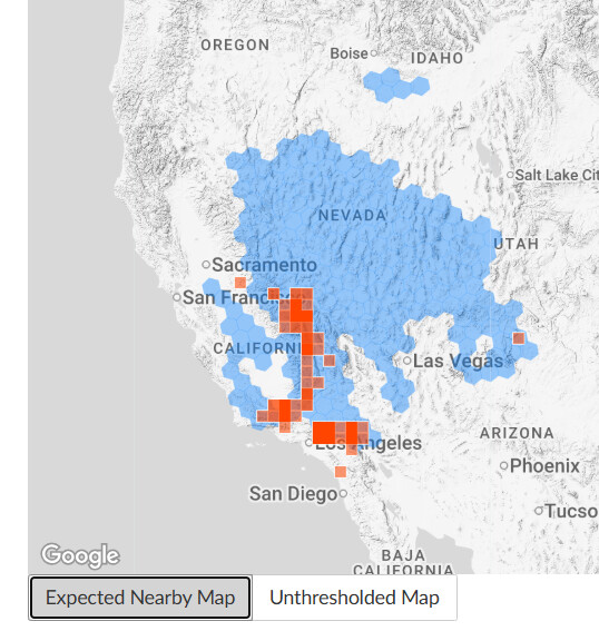
Map of records for Bossiaea stephensonii (only found around Sydney and immediate surrounds). You can see there are basically two main ‘populations’/clusters: a diffuse cluster up between Sydney and Newcastle, and then a tightly packed one down south of Sydney. Importantly, note that of the 214 total records, 137 of them are in that southern cluster.
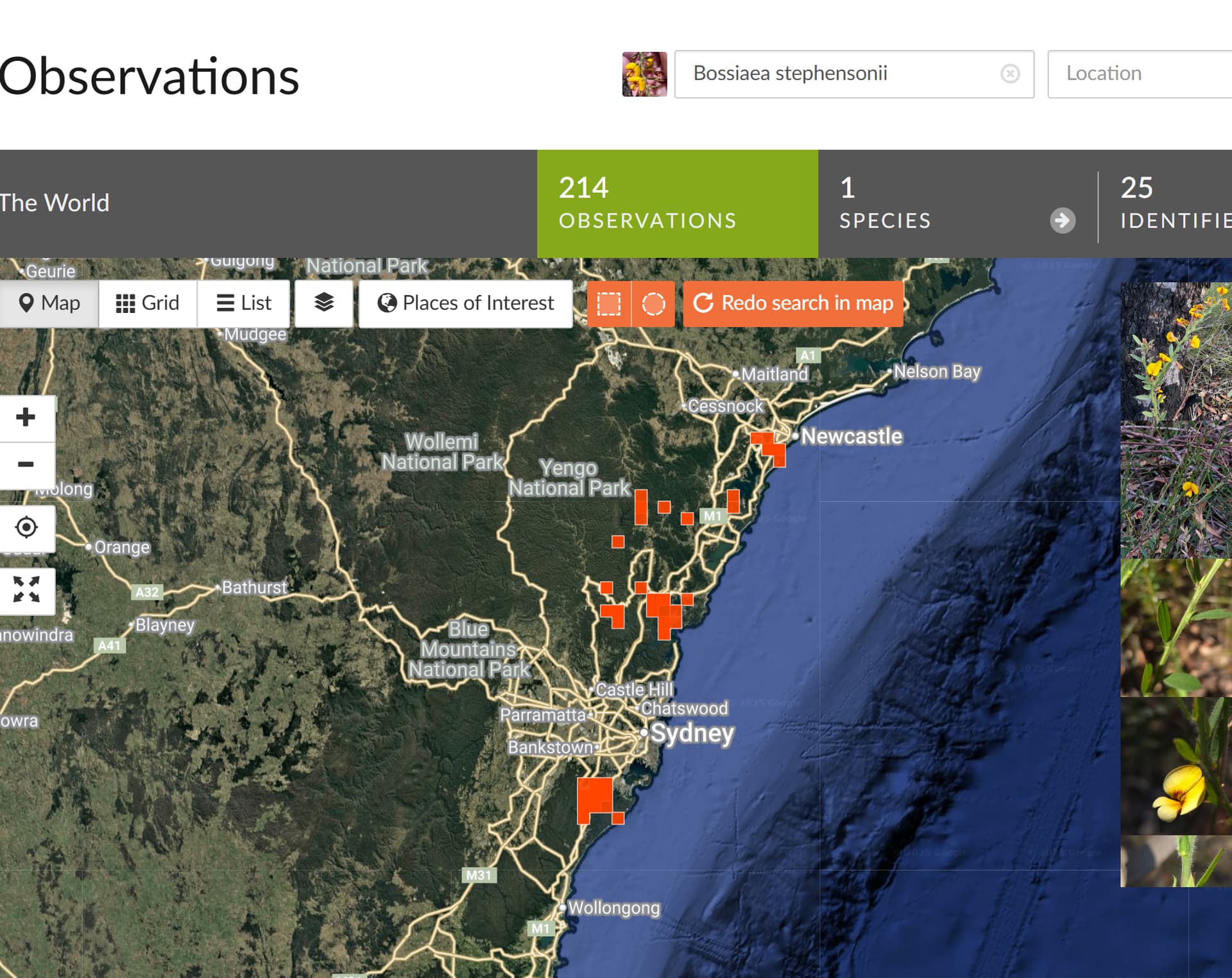
now compare that to the expected nearby map. The southern cluster is somehow completely omitted and does not have a filled in cell at all, despite that area containing ~65% of all the records

and I’m pretty sure this is only a recent change, as I’ve uploaded numerous records of this species from the southern cluster previously, and I recall it being suggested as seen nearby as would be expected
5 Likes
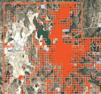
We have a similar map for Cape Peninsula - where the 2 adjoining hexagons exclude Hout Bay. It is mostly in the ocean, so the Geomodel ignores that bit? There needs to be a THIRD hexagon for the missing bit. Hexagons are fixed and universal - not specifically for this sp, and for these obs - if I compare maps across sp.
I worry how many 10s of 1000s of misidentifications it is causing.
1 Like
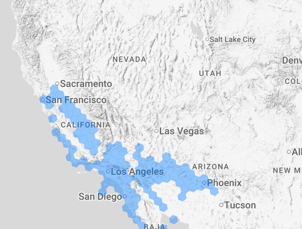
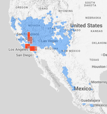
Hi there, I have another example: https://www.inaturalist.org/geo_model/489730/explain
The most interesting area is east of Salt Lake City, Utah.


The only thing that could make sense is that the model is also considering occurrences of Coleoptera, which sort of matches the shape of the hexagons and it’s shifted to the east. But anyway, it’s just a hunch, nohing of substance and I’m sure there’s all sort of oddities.

Or Family:

2 Likes
We released a new version of the CV and Geomodel today, 2.23, with some fixes, and a new blog post that includes some details of what happened and what next steps are. I do want to apologize for the issues this last version caused.
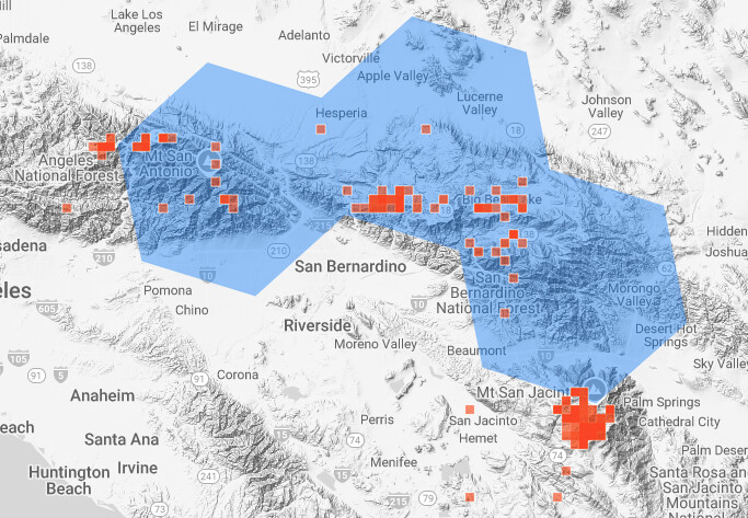
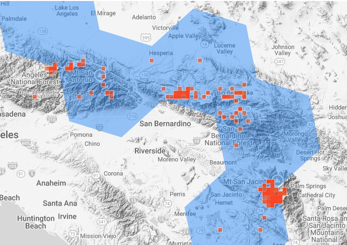
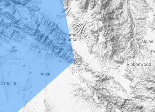
I’m not too familar with San Jacinto Peak itself, but I’ve spent a decent amount of time below it and it does provide some real challenges when using elevation to make predictions. According to Wikipedia,
The steep escarpment of its north face, above Snow Creek, climbs over 10,000 feet (3,000 m) in 7 miles (11 km). This is one of the largest gains in elevation over such a small horizontal distance in the contiguous United States.
(other desert sky islands are probably similarly problematic, depending on how the hex cells shake out)
One thing I noticed with the previous model is that it didn’t predict red diamond rattlesnakes in the cell just north/northwest of San Jacinto, even though that cell contains a popular herping road with many observations of red diamond rattlesnakes on it. That cell is covered now, which is good, although the areas north, where the species doesn’t occur, are also expected nearby. Something to definitely keep working on, and it will be good to use areas like this as test cases.

The woodland pinedrops map does now cover the cell southwest of San Jacinto Peak and the CV suggestion for the observation in the OP now, but it would be good for the cell just to the east to also be covered in the future, it looks like.

FWIW, I don’t see that area in the expected nearby map in the new version.
9 Likes
The new map looks much more realistic. The team definitely got rid of a lot of gremlins.
Awesome work.
1 Like
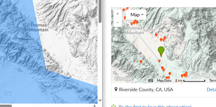
Comparison of Pterospora andromeda.
Before:
After:
So, somewhat of an improvement in that area but still needs work and possibly made it worse in other areas.
2 Likes
For Crassula thunbergiana Expected Nearby map carefully excludes the hexagon for the Cape Peninsula. Too much South Atlantic Ocean? Unthresholded still excludes the Hout Bay bit in the even more oceanic ‘gap between hexagons’?
“All models are wrong, but some are useful.”
5 Likes
Thanks much for taking this problem seriously and implementing at least a partial correction so quickly! Both are much appreciated. I’m very glad that iNat is continuing to think about how best to make CV predictions in areas with significant elevation variation. It is a difficult problem to deal with.
2 Likes
Platform: web site, on Google Chrome on iOS 15.3
App version number, if a mobile app issue:
Browser, if a website issue: Google Chrome
URLs (aka web addresses) of any relevant observations or pages:
Screenshots of what you are seeing:

Description of problem:
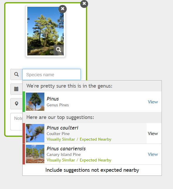
Step 1: I think the AI has gone nuts. I was creating an observation of a large pine tree in Riverside County, CA. I added my photos and let the AI suggest a pine species. It selected as “common/expected” 2 non-native species (with no RG observations in this area), a pine disease, and one native pine that has 7 RG observations in the county. There are at least 3 other similar pine tree contenders with many, many observations in the county that weren’t mentioned. That includes the species I was told was “the” big-coned pine tree in the area, the Jeffry Pine.
It’s the “common/expected nearby” business that threw me. Why are two non-natives with a handful of “needs ID” observations listed in that state?
Step 2: Here is the observation: https://www.inaturalist.org/observations/302809406
Feel free to copy the photos and try it for yourself.
1 Like
same here Vaccinium angustifolium (lowbush blueberry) on July 8, 2021 at 01:17 PM by Robert Levy · iNaturalist. it’s a common species but only shows up under “Visually Similar”.
Sometimes you need to remove the “Expected Nearby” label and look at the Visually Similar only.
P. jeffreyi is the first one when you look at all species, not just expected nearby.
3 Likes
Here are the suggestions for that photo/location after the latest computer vision update:
And here are the updated geomodels for species now excluded from the suggestions for the observation:
Pinus brutia:
https://www.inaturalist.org/geo_model/135778/explain
and Pinus attenuata:

It looks like the geomodel for Pinus jeffreyi (which the observation was IDed as) still excludes that specific area, so the it not being included as “expected nearby” is “working” as designed, as in, the geomodel doesn’t expect it nearby, so it isn’t included in the default results. Not great, but the model is under regular revision.
3 Likes
I’ve noticed some weird extrapolation of vagrants. For instance, the model expects Eurasian Eagle-Owls around Great Salt Lake. As far as I know there has never been one anywhere near there and there certainly aren’t any obs there on iNaturalist (the closest are in New York City). I imagine this is not intended behavior. It also expects American Robins throughout Ireland and nowhere in Britain, despite all observations occurring within the British Isles occurring in Great Britain or Scilly.
2 Likes