CV suggestions have gotten much, much worse at San Jacinto Mountain

100%. I don’t know if there is a feature request for this, but it would definitely help reduce the issues of species being shown as “expected nearby” when they don’t even occur on the same continent. Clipping the geomodel maps to some reasonable buffer (100 km?) around existing Research Grade observations would be a good step.

5 Likes

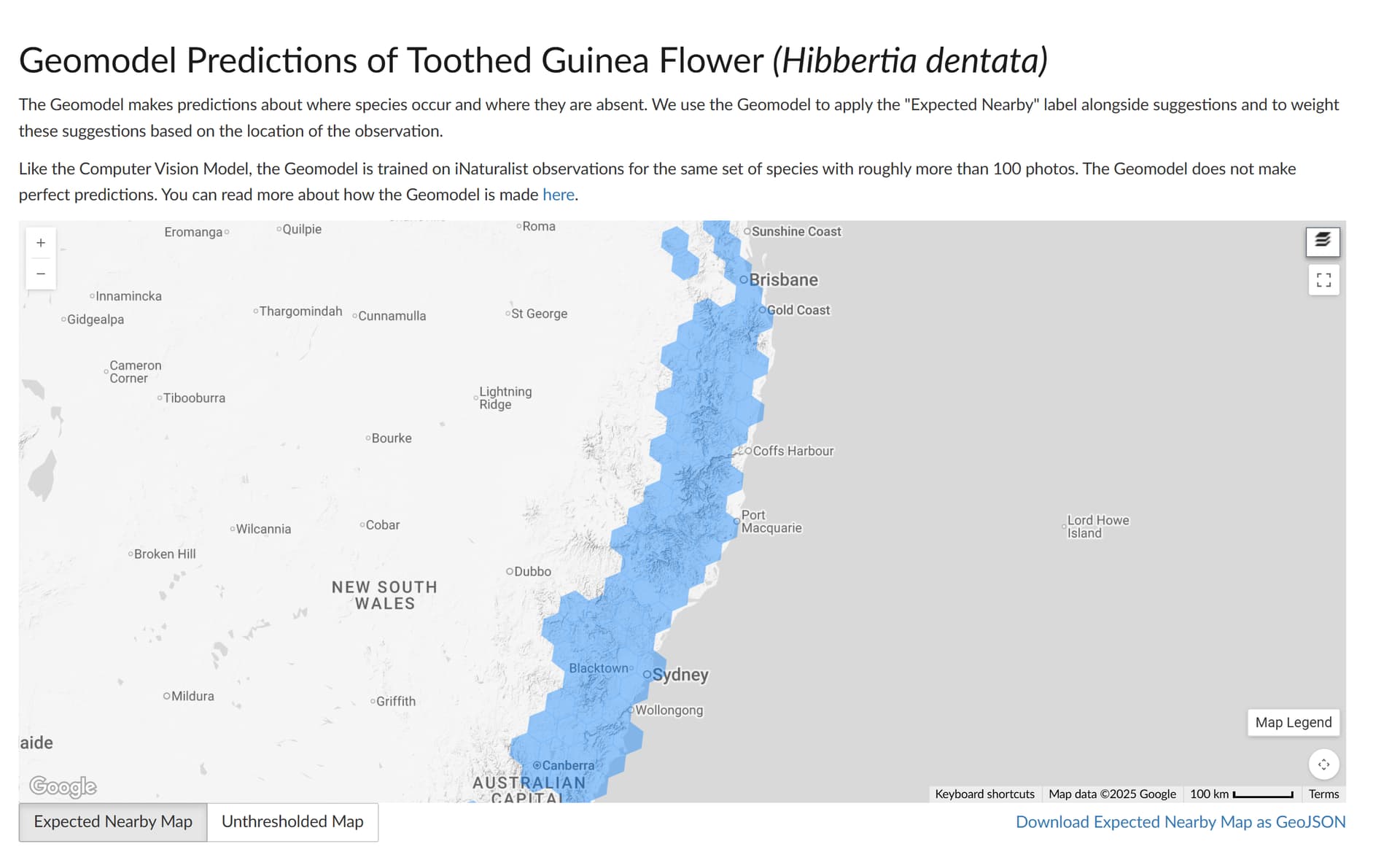
as a similar, frustrating example to the Bossiaea stephensonii one I raised above, here is the current expected nearby map for Hibbertia dentata:

there are hundreds of RG observations from all of those coastal cells that are currently being excluded, many of them that have been in iNat for years

2 Likes

Who has inherited this? Since Alex is no longer iNat staff.

@dianastuder please see my post here.

We just released an update to the model and we’ve gone back to using the grid approach. The maps are looking overall better to me, eg for Hibbertia dentata this the new map, which covers the coast:

In the previous model this coastal observation was not getting a Hibbertia dentata suggestion but it is now, which is good.

The Crotalus ruber map is also tighter and doesn’t go way far north out of range for the species like the last version did.

But like any model it’s still not perfect and the observation in the OP here is now again just outside the expected nearby range. We’ll keep working on improving it. I suspect a lot of the San Jacinto problems have to do with both the area’s extreme changes in elevation and an unlucky placement of grid cells in the area.

8 Likes

Yes - thank you - have been waiting for that CV update.

We currently live in a hexagonal world…with all its joys and warts.

3 Likes

Yeah we are living in a hexagonal world…

1 Like

My Cape Peninsula has regained the Hout Bay hexagon, which is mostly South Atlantic Ocean. :grinning_face_with_smiling_eyes:

Hexagons are the Bestagons

https://www.youtube.com/watch?v=thOifuHs6eY

3 Likes

6 posts were split to a new topic: How do Computer Vision results get sorted in the Suggestions/Compare Pop-ups?

Yay! Thanks for reverting to a model that worked much better. I’m impressed you did that.

When I have time, I’ll try to remember to check some of the San Jacinto Mountain cases, but since it was very clear that the older geomodel was much better, many of them should now be improved.

1 Like

While the topic has been marked “solved,” and evidently the updated model improved the accuracy, I want to flag that I see similar issues with the geomodels for high-elevation conifers in the southwestern US.

For example, Abies lasiocarpa and Pinus flexilis are well-documented (by RG iNat observations) in the Sandia Mountains, but neither geomodel includes this regions. For Pinus flexilis, the geomodel extends far beyond the documented range, through the Grand Canyon. For Abies lasicarpa, the geomodel misses part of the North Rim of the Grand Canyon and also some peaks in the Gila National Forest, the Pinaleño Mountains, and the Santa Catalina Mountains.

Are people continuing to notice geomodel anomalies for species with similarly scattered, high-elevation ranges?

1 Like

I guess the most efficient way to package something is a sphere (you basically shrink-wrap it, like a water droplet). But spheres don’t tessellate, meaning, if you cover a kitchen floor with exercise balls, then you get a lot of wasted space between the balls.

So a hexagon is the closest shape to a sphere, that neatly covers a floor with no wasted space.

I think this has been explained to me before, but I forgot, so I’m leaving it here for anyone who didn’t know, and also for myself, for future reference.

If you think of a dome, like a yurt, it makes sense WRT maximizing space, and you can see these patterns everywhere.

2 Likes

https://youtu.be/thOifuHs6eY?si=MtXQQ9Sgu9a9bkiJ

Well, to be a bit pedantic, you can tile a plane by regular hexagons, but not a sphere, which is what the map really depicts. In contrast, you can tile a sphere (but not a plane) by pentagons, but I think the only way to do it is with exactly 12 pentagons—not so useful for an iNaturalist geomodel, which ought to have quite a few tiles.

1 Like

I found another example where the geomodel is still working really badly in the San Jacinto Mountains and nearby Palomar Mountain. Check out Ribes nevadense. With the hexagons, it almost looks like they are wiggling around trying to avoid where certain hotspots of this species are.


I still can’t believe they don’t have a basic quality check that adds in any hexagon that has a bunch of observations in it.

6 Likes