I am a new user to iNaturalist (been using it for about 8 months and have about 200 observations). I recently tried to locate a plant in one of my observations using the map in the app on my Android phone. It got me fairly close but the plant was actually about 40 steps north of the red symbol on the map. I searched using Google to see if I could find out more about this in iNaturalist. I’ll be honest here: I couldn’t understand half of what most of the forum posts were saying. The Help does not mention this except to talk about obscuring locations which at this point I am not interested in doing. In this forum post: https://www.inaturalist.org/projects/dfw-carnivores/journal/2035-observation-location-accuracy, the writer says, “If you record the location with the iNaturalist app, then it assigns the accuracy automatically. However, if you assign the location using the metadata from a photo (e.g. pictures taken on your phone contain information on your location), or by manually mapping it through the web interface, then you need to add the accuracy by editing the observation.
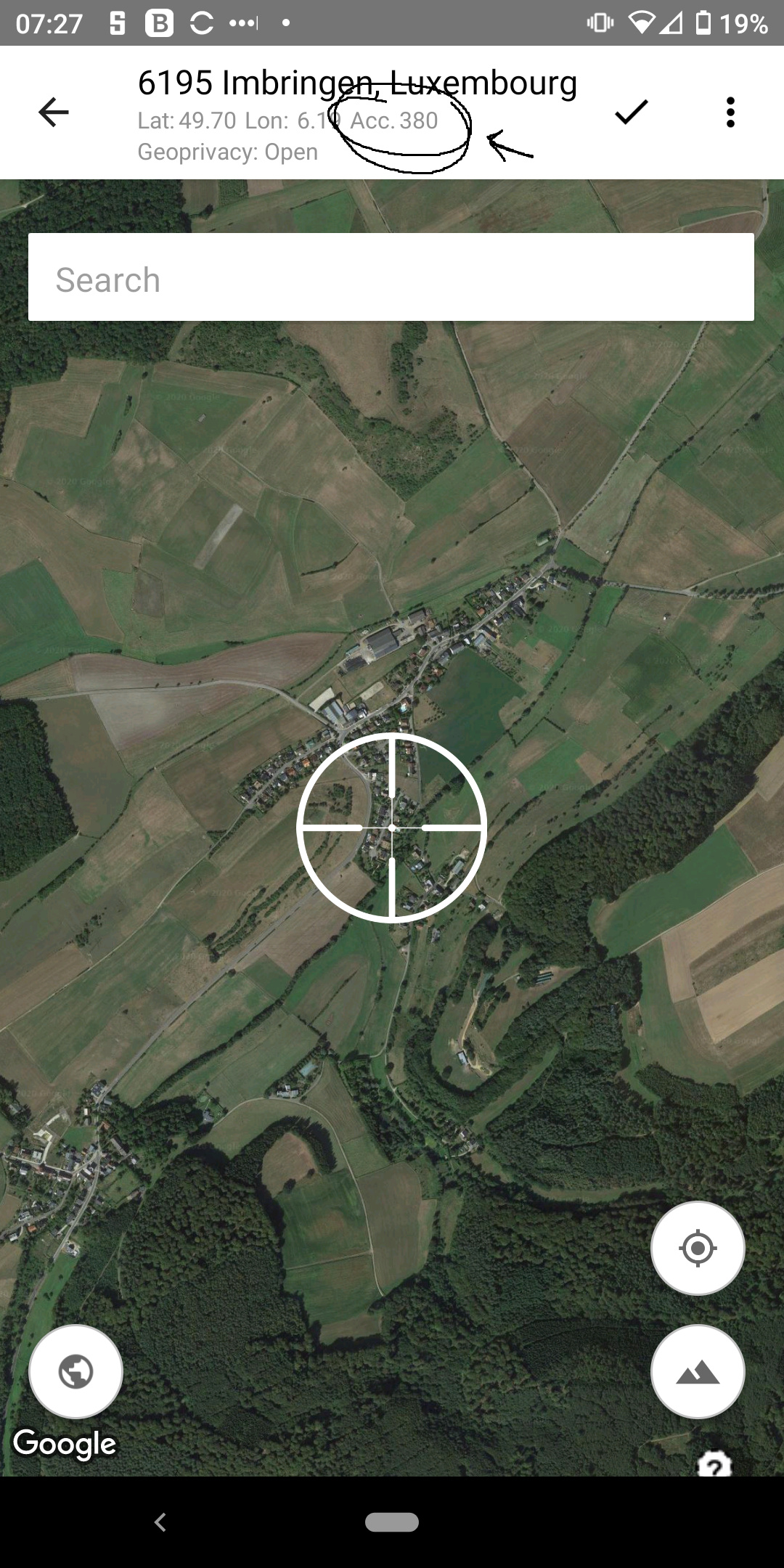
The accuracy field, labeled “Acc (M)”, is located directly below the coordinates, and just above the map.” What?! First of all there is no such accuracy field in iNaturalist on my PC or on my phone. Why isn’t the location from my phone good enough? Is there a simple way to improve my phone’s accuracy? Thanks for your advice.

Look at the line «точность м.», it should be an accuracy for you.
Phone can get ridiculous data, for higher accuracy I turn off the Internet and use only gps, you also can download a geo app, I heard there’re many of those. You can move the circle right where you want it if it wasn’t close enough, I never changed the accuracy line, only was moving the circle and adjust its size.
I have that problem. I only use the Android app and a lot of the things mentioned in posts are either not there in the app or are called something else. I’ve never seen an option to change the accuracy.
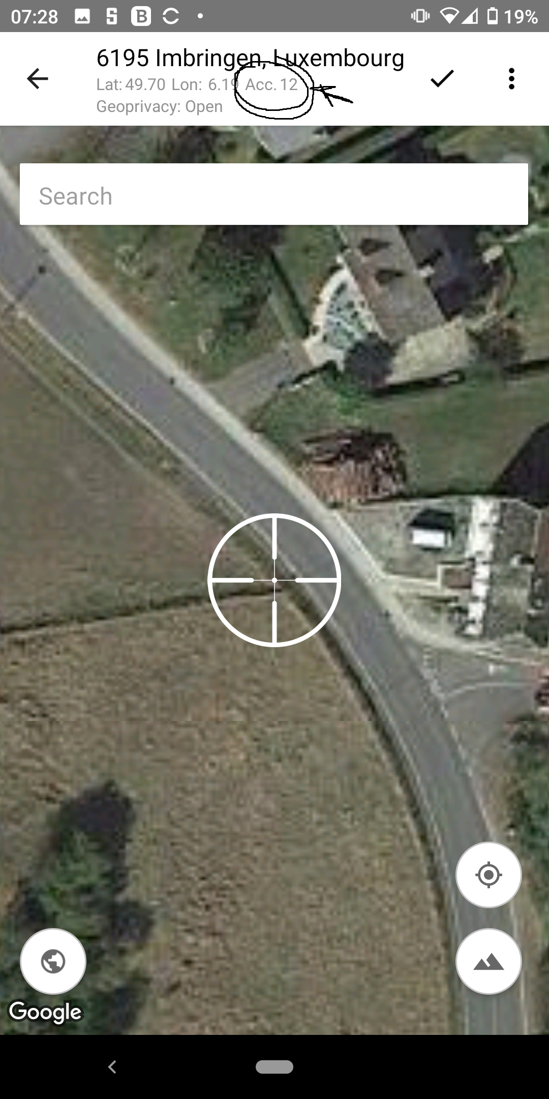
In my experience the only way to get really tight accuracy is to manually adjust it. On mobile use the default, then zoom in and move to the location you want to set at the accuracy range you want to set.
In the browser use the map to zoom in and click the location when you’re in tight enough (you can also adjust the accuracy circle using the handles).
Generally I’m not a fan of trying to place the pin exactly on the location as there are inaccuracies in the Google imagery that’s used (time of day and where the satellite or plane was can mean differences of 10 meters or more). In terms of usability of data it doesn’t really help all that much to have a tiny accuracy circle, especially given the inherent errors in the map used.
20-40 meters is generally fine for the purposes of iNat.
On the app (android) there is no field “accuracy” that you can adjust by entering a value. Accuracy is adjusted by resizing the circle on the map, the more you zoom in the more precise your location gets.
So you have been changing the accuracy @marina_gorbunova by adjusting the circle.

my phones GPS is sometimes a bit slow to “wake up” making the first GPS readings sometimes very inaccurate.
I don’t think there is a way to improve the accuracy of the GPS reading you phone is able to get, it depends on hardware, satellites available, you surroundings etc. but generally the readings are more accurate when wait a bit after “waking up” your phone.
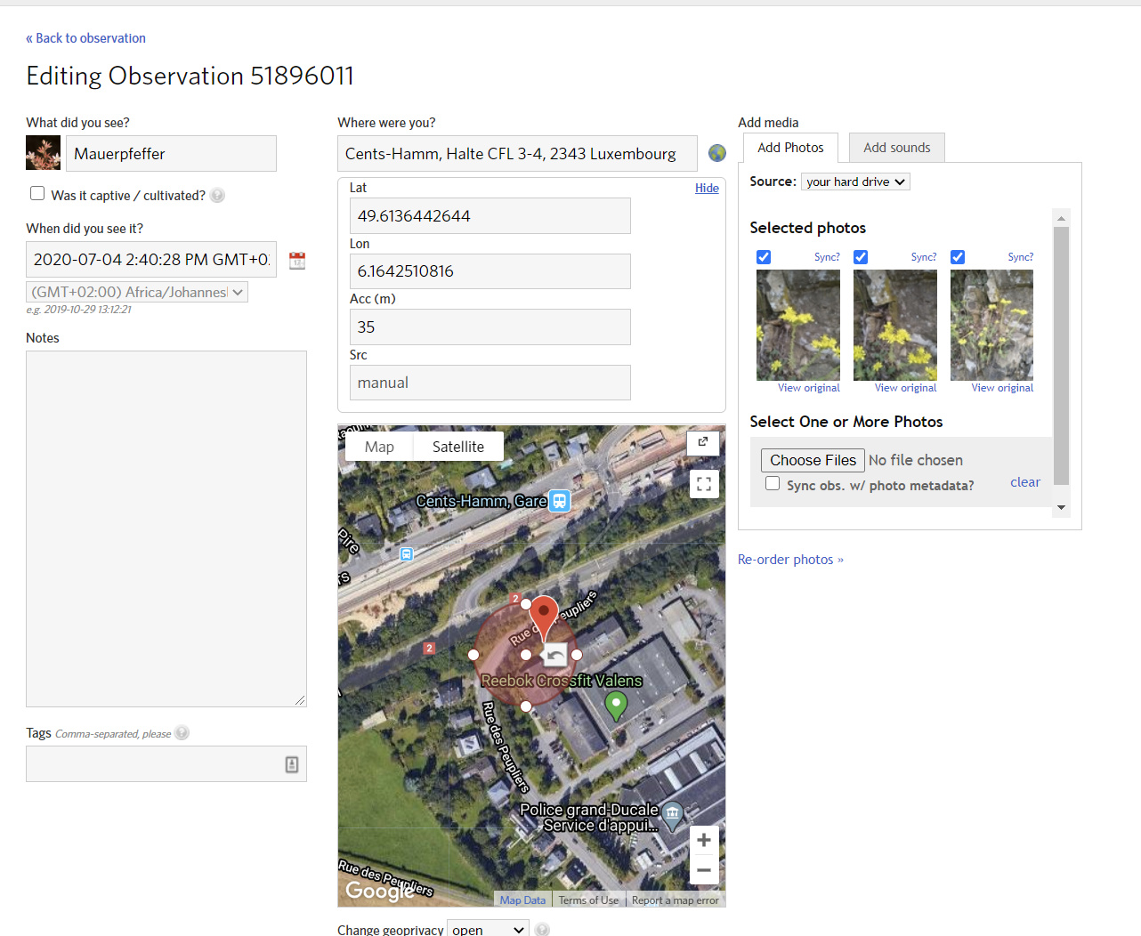
If you take an image using the phones camera (not using iNat app) the phone (depending on you settings) writes a GPS location into the images metadata, if you then upload the image to iNat there will only be coordinates, no accuracy. You can edit the observation to add the accuracy as sown above. The same happens when you geotag images taken with a “real” camera and upload them via the webbrowser.
on the web you can enter the value manually or also adjust the circle to change it.
Now when you try to locate an existing observation you basically have to take into account the inaccuracy of you current GPS reading and the one made during the observation. typically your phones GPS accuracy is withing 5m https://www.gps.gov/systems/gps/performance/accuracy/#:~:text=For%20example%2C%20GPS-enabled%20smartphones,receivers%20and%2For%20augmentation%20systems
so basically if you wisite the same location twice you will get different readings
I never said you can edit the field in the app by typing.
I just wanted to make clear that by resizing the circle one is adjusting the accuracy.
:-)
Just wanted to show that accuracy is adjusted by the way you have described, someone might understand you sentence as “you cannot adjust the accuracy”.
This is a function of GPS and how it works. The accuracy of a GPS reading is determined by how many GPS satellites your phone can see along with how long your phone is actively looking for a GPS location.
I always pull up a third party GPS app that shows me the locations of all the GPS/GLONASS satellites in the sky along with current accuracy reading. I then go into iNaturalist and enter an observation. On the location screen I repeatedly hit the get location button until it stops moving.
It’s not a very fast workflow and if I did this professionally I would probably research some other methods using always-on high accuracy external GPS and some scripting to merge GPS points with date/times on individual photos before mass-uploading to iNaturalist.
Yep, a lot of my observations are from McKinney Falls State Park.
The GPS is pretty accurate when I’m at the parts of the trails that run nearer to buildings (TPWD HQ, city streets with stores, etc), but I always have to adjust my location on the observation when I’m in deep among the trees or near the falls.
Ah, sorry, misunderstood your sentence, yes, when the circle changes the field changes too.
With a phone it’s not just the satellites, doesn’t matter what app you use. Phones tend to have fewer communication bands dedicated to communicating with the GPS satellite, so they’re less accurate inherently, so they try to get around this by using the cell-phone tower relays to improve accuracy, but it’s still not as good as a dedicated GPS (except for in a few specific situations)
Look at the difference between GPS and A-GPS:
https://www.diffen.com/difference/A-GPS_vs_GPS
With consumer-grade GPS, you’re going to have big accuracy issues whenever you don’t have an unobstructed view of the sky. Even a few trees nearby or being inside a canyon will affect accuracy.
The GPS tracking app I use graphically shows me a circle showing the detection ability of the phone’s antenna as well as all satellites. I literally will hold phone up over my head and rotate it slightly to get as many satellites as possible inside the antenna circle. Takes a couple minutes but I usually get accuracy down to under 15 meters this way.
I just go to edit the location immediately and zoom in the location on the satellte view. The aerial shot of McKinney Falls State Park is clear enough that I can find showing exactly where on the trail I was when I made the observation (E.g., “It was after that bend, before the switchback, so…right here!”).
On the other hard, I’ve visited a teeny bit of Alaska & Cinque Terre, and in both of those service was spotty enough that I sometimes didn’t get service until back in a larger town, and then had to go off my memory of what the terrain looked like on the ground and try to translate that into the overhead views to set my location “pin”. A GPS tracking app would have probably been handy in those cases.
Thank you so much!!! I now have a clue!! I haven’t ever taken a photo from inside the iNat app. I will try that just for fun. It isn’t all that important to me to have them be totally accurate but I like to understand how things work. Really appreciate your taking the time to help me.