Different amount of records and species in the same location (Square selection and custom selection)

Please fill out the following sections to the best of your ability, it will help us investigate bugs if we have this information at the outset. Screenshots are especially helpful, so please provide those if you can.

Platform (Android, iOS, Website): Website

App version number, if a mobile app issue (shown under Settings or About):

Browser, if a website issue (Firefox, Chrome, etc) : Opera

URLs (aka web addresses) of any relevant observations or pages:
https://www.inaturalist.org/observations?nelat=49.54328269271285&nelng=5.8271372828297086&place_id=any&swlat=49.54232545554192&swlng=5.823169759058429&user_id=francisbirlenbach&verifiable=any

https://www.inaturalist.org/observations?place_id=164653&user_id=francisbirlenbach&verifiable=any

Screenshots of what you are seeing (instructions for taking a screenshot on computers and mobile devices: https://www.take-a-screenshot.org/):


Description of problem (please provide a set of steps we can use to replicate the issue, and make as many as you need.):

Step 1: I created a new location “Francis’ garden” instead of using the square selection tool on the map.

Step 2: Now, for the same location , I have different amount of observations and species

Step 3: Square selection on the map :1830 observations 992 species (That’s the right one)
“Francis’ garden” selection : 1640 observations 935 species
Note : There are no other observations outside “Francis’ garden” selection that could explain the difference.

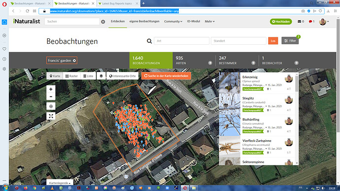
1 Like

Hi @francisbirlenbach, I wonder if this might explain it? https://www.inaturalist.org/pages/help#placeindex

Essentially - you may need to make the uncertainty circle around some of your observations smaller (or your place bigger).

this might help identify which ones: https://www.inaturalist.org/observations?nelat=49.54328269271285&nelng=5.8271372828297086&swlat=49.54232545554192&swlng=5.823169759058429&user_id=francisbirlenbach&verifiable=any&not_in_place=164653

1 Like

Thanks to both of you. That could be the reason. I will check those observations. How can I prevent that error in the future? Is it a fault I made when I entered my observations ? I do not know why some of them have a larger uncertainty circle and others are “regular”. I’m not using automatic area infos from a GPS.
I enter all of them manually by clicking exactly on the place on the map where I found them.

the default accuracy value varies based on how far into the map you have zoomed. try different zoom levels, and you’ll notice that the accuracy value that is populated when you click on a location in the map is 1m at maximum zoom, 2m at the next zoom level, 4m at the next zoom level, 8m at the next zoom level, and so on…

you can also override the accuracy level to some value of your choosing, too, by simply typing in a new value in the box.

1 Like

Thanks, will do that in the future :-)

2 Likes