Let’s say I come across a beaver dam (or other easily identifiable animal signs); can I post those observations, even when the actual animal was not observed directly?
Yes, scat, tracks, ‘homes’. bones, feathers etc are all acceptable and considered as evidence of the presence of something. There are even observation fields, in particular one called ‘Sign’ where you can record exactly what it is for search purposes (I am sure there are other Observation Fields doing the same thing, that looks like the most common though)
Thanks, hadn’t realized I could add observations fields outside of a project… Looks like there’s “Sign”, “Track or Sign Type”, or “Type of sign” to choose from 
A recent obs was an installed bat box. I was told that counts as evidence of Homo sapiens, but not of bats.
I’m sure many bat boxes go unused, so unless there was guano or other evidence of actual bats making it their home, makes sense to me to identify as human.
A beaver dam is part of the “extended phenotype” (to use Richard Dawkins’ term) of Castor canadensis. Some distinctive nests of certain birds may also be identifiable to species as well as the “houses” built by caddisflies. As sign these are different than tracks or scat which are not constructed by the organism but merely left behind. Maybe one day iNat will also include DNA barcode records obtained from swabs or environmental DNA, which would also be sign left by an organism.
A tree that has been obviously chewed or felled by a beaver would also count as sign. Not all beavers build dams/lodges.
Yes people keep on insisting on re-inventing the wheel when it comes to fields. One of the most long standing for indirect evidence is “Animal sign and song” http://inaturalist.org/observation_fields/24
Getting off topic, but there is a field “inanimate object” that is useful for marking observations that are just really recording the location of a trap or animal nestbox etc https://www.inaturalist.org/observation_fields/1900 (but mark the observation as “no evidence or organism” too if it is unoccupied etc)
A semi-related note. There is an “Animal Architecture” project that you can add beaver dams, spider webs, wasp nests, and other animal constructs to.
I wonder: in northwestern Canada, there is a beaver dam so large that it shows up on satellite photos, including those associated with Google Maps. It’s so remote that I’m not sure anyone has ever seen it in person—not that they’ve recorded, anyway. I wonder if anyone has used the satellite photo to log it as an observation.
If I recall correctly, the precision of its location would be somewhere on the order of Hadrian’s Wall. It’s miles long!
You could post an imageless/casual grade observation of the beaver dam (ensuring the date “observed” matches the date the image was taken), but uploading the aerial image itself would likely be a copyright infringement.
The approx coordinates are: 58.27217, -112.25263, should anyone wish to post it. WSW of the southern tip of Lake Claire, Wood Buffalo Natl. Park, northern Alberta.
I’ll note that many, if not most, beaver dams are identifiable from satellite imagery. Here’s a random photo from Google Earth where I’ve indicated 7 visible beaver dams:
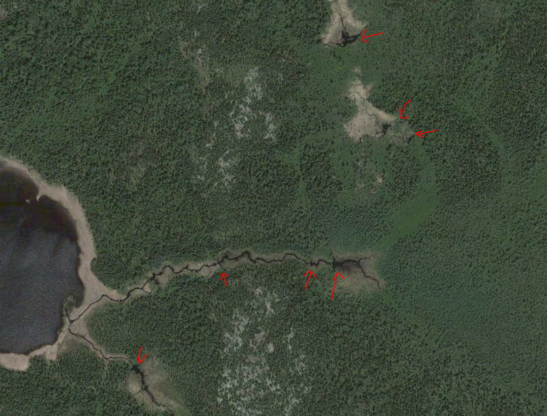
And indeed I can see dozens of visible dams within a few kilometres of that extra long dam mentioned above. But that dam is certainly something special though, looks to be about 800 m long.
It’s so big and special I think Sarah Palin can see it from her back porch.
Maybe, maybe not. Much of the imagery that google uses is from government sources. The roads and other parts of their maps are products they created but the imagery is not. Might be difficult to grab just the imagery though. Something like SARtopo.com might be a solution, the use openstreetmaps. Or maybe iNat website itself.
Another work-around would be to pull up the same location using a government website and use their screenshot. Try looking for property tax mapping website for your local government area. https://maps.raleighnc.gov/iMAPS/
And one final comment that map help when searching for other sources of imagery. Despite google calling this “satellite”, in the USA and many other developed places, the images are aerial photos taken from planes. Search for “aerial imagery” and you may find a good source of copyright-free images.
I map beaver wetlands among other things at work. I think I even have noted a few on inat but really we are getting into natural community mapping here and need polygon functionality which is probably getting beyond what the devs want inat to do :)
Or they do get used, but not by bats! (eg. wasps build nests inside them, etc.)
I often find Banded Caracol snail shells in my back yard under a tall tree. I have never seen a living snail there, so my feeling is that a snail kite is dropping them while perched in the tree. But I have never seen a kite either, so I hesitate to identify either. Could it be another bird? Did the snails crawl there and die?